


The area around Petroșani is very attractive for motorcyclists. There are many beautiful roads both paved and unpaved. We have the Jiului Gorge, the road to Valea Cernei, the road to Obârsia Lotrului and a little further Transalpina. For off-road enthusiasts we have the TransVâlcan, the road to Valea Cernei, the road to the Sohodol gorges, and the road that goes up from Petrila to the Șureanu ski domain (https://2ride.eu/en/segment/off50-sureanu-petrila/). A little further is Strategica military road (https://2ride.eu/segment/off14-strategica/). You can find all the offroad segments on our website or on the YouTube channel.
The paved portion
The road between Câmpu lui Neag and Cerna-Sat is one of the most spectacular routes in the Romania for motorcyclists. It crosses the southern part of the Retezat Mountains and connects the West Jiului valley with the Cerna river valley.
Let’s take it one at a time.A first paved part starting from Câmpu lui Neag. It is about 20 km with fairly good asphalt. The plan was to pave the entire road to Valea Cernei, but because the road crosses a protected area, there were protests and the works were stopped. So being a road that leads to nowhere, the traffic is very low, even though it is a national road. This first section is very relaxing: you will have wide turns, some with good visibility some less. The landscape is varied, there are also open sections where you can see the peaks of the mountains, but also sections with a gorge appearance where the cliffs approach within a few meters of the road.
The unpaved portion
Approximately 20 km from the intersection with the road coming from the Sohodol gorges, the asphalt ends abruptly. Be careful because this place is not visible, being located at the top of a slope, at the end of a fairly long straight line.
The macadam road is relatively ok. There are some rougher sections with lots of big rocks but generally you won’t have any problems.
At first we will climb for about 3 Km until we reach a clearing. Here is the point of maximum altitude of the route located at approximately 1400m.
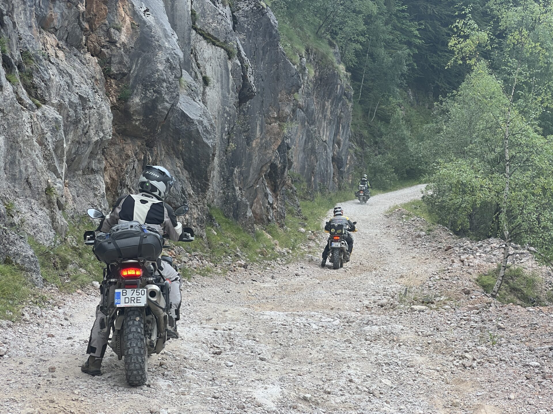
Then the road begins to descend gently, gently towards the valley of Cerna. About 7 km from the clearing we reach the most spectacular point of the route – The Red Cliff. Here, in the vicinity of the Ciuceava Mare peak, the road is simply dug into the rock because otherwise it could not bypass this massive cliff. Thus for a short portion we leave the forest and can admire the surrounding mountain peaks.
Immediately after this viewpoint, the most difficult part of the route follows. Don’t be scared, it’s only about 100m of a slightly steeper slope with bumps and large stones detached from the ground. Especially if you go downhill it will be easy to pass.
Further, the road descends through the forest. There will be nothing out of the ordinary until you reach the edge of the Cerna River valley. From now on the road goes quite straight and without big differences in level.
We will come to an intersection just before a bridge. We will have to take a right on the bridge to continue on the banks of the Cerna reservoir. Now the road follows the level curve of the lakeside until we come out at the dam. This last section can be quite challenging as there are many areas where mud can form.
From the dam to Cerna Sat and further to the junction with DN67D the road is quite good for an unpaved road especially as it is well paved and does not form mud.
Similar roads

OFF09 Gruiu Vidraru (TET Romania)
OFF09 Gruiu Vidraru (TET Romania)

OFF13 Oltețului Gorge (TET Romania)
OFF13 Oltețului Gorge (TET Romania)
